
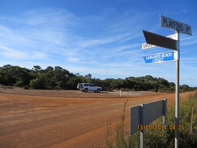
The highest point on Kangaroo Island – 307 metres asl – just in the bush behind the car
If you have a look at a reasonable map of Kangaroo Island there is a dot indicating the highest point on the Island. The dot is on the corner of Playford Highway and Snug Cove Road. The summit is un-named. VK5PAS, Paul and VK5AKH, Andy activated this summit in August 2013 in weather which even the ducks would complain about! We were more fortunate with the weather. It was a warm day and a shirt without jacket was fine.
I was able to enjoy twelve contacts on 7.090 beginning at 04:22: VK5TW, Trevor; VK5ZGY, Greg; VK5GJ, Greg; VK5LI, Craig; VK5FD, Allan; VK3AMB, Bernard; VK5WG, Nev; VK5BC/M5, Brian; VK5KLV, Les; VK3BHR, Phil; VK5FAKV, Shawn and VK5PI, Mark. This is an easy summit, with the high point being just off the road, behind our vehicle, in the trees.

Hi John,
This is one of those strange ‘summits’, I’m sure you would agree. It is only there because it is the highest point on the island and therefore has prominence. But when you compare it to other hills which don’t qualify, well you have to start wondering? Anwya, congratulations on the activation and I am very pleased the weather was much kinder to yourself and Jenny, as compared to Andy and I. Yes it was miserable August weather when we were there.
Best 73,
Paul,
VK5PAS.