
This certificate recognises 44 contacts made by me with operators in 44 parks. That is, the contacts were made while we were all portable. Thanks to the other park operators who make these contacts possible.

This certificate recognises 44 contacts made by me with operators in 44 parks. That is, the contacts were made while we were all portable. Thanks to the other park operators who make these contacts possible.
Here is my certificate for making contacts with amateur radio operators in 308 parks. It was a lot of fun and hard work on occasions as band conditions have deteriorated.
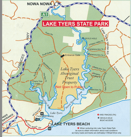
Lake Tyers State Park is just a few kilometres from Lakes Entrance and after a visit with our son and his family to Lake Tyers Beach, a walk and lunch at the Take Tyers Beach Tavern, we thought we should visit for radio and bird-watching purposes. ‘Lake Tyers State Park extends from Lake Tyers Beach to Mount Nowa Nowa. Tall eucalypt forests surround the northern shores of Lake Tyers, and a thin sand spit divides the lake from the ocean’ State Government Parks Brochure.
Now I can relax!
We actually spent time at the park on two subsequent days: 23rd and 24th April. On the 23rd April we drove to Lake Tyers House Road and followed the road towards the sea. The map shows four roads/tracks into the Park. We drove down a track closer to the Highway (the Parks Guide called it Devils Hole Track) and not quite as far in as Happy Valley Track. The four wheel-drive track was quite sandy and care is needed as it was soft. We came to a clearing and I set up there. The bush was magnificent although not like the rain forests of the mountain parks. This track does not provide access to the water.
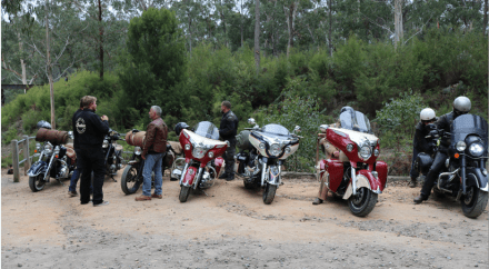
Before arriving at the Park with our family we visited the Stony Creek Trestle Bridge on the now closed Orbost line. The bridge is 276 metres long and 19 metres high and was built early in the 20th century. It is only about four kilometres from the highway at Nowa Nowa and is well worth a visit.
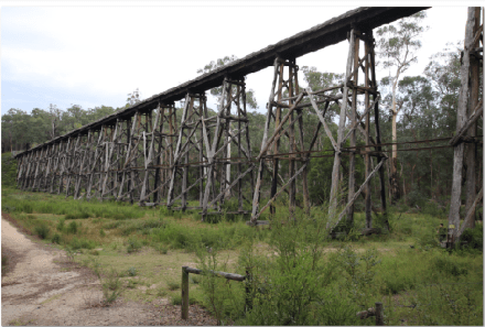
While there the Veterans’ Motor Cycle Club arrived to visit the bridge. These folk all had Indian motor-cycles, both new and vintage. It was a most impressive display of these wonderful machines. I was given a most informative tour of the motor-bikes and they invited me to take some photos.
Day One Contacts
04:58 VK5FMAZ/P Marija at Cooltong Conservation Park, VKFF-0823
VK5PAS/P also Cooltong Conservation Park
VK2KYO
VK3VLA
VK7DW
VK1AT/3
VK3FPSR
VK7JON
VK2NP
VK5KLV
VK3SQ
VK4FW/P Nour Nour National Park VKFF-0701
VK2LX
VK4GSF
VK3VIN
VK3TKK
VK5WG
VK4RF
VK4HA
VK4AB
VK7FOLK
VK5HYZ/P Scott Creek Conservation Park VKFF-0788
VK2EXA
VK3HSB
VK3YSP
VK3FOWL
VK2UCT
VK3PF/4 D’Augilar National Park VKFF-0129 & VK4/SE-043
VK3MNZ
VK3FSPG
VK3MPR
VK3ANL/P QRP VK3/VU-002
VK3CWF
05:48 VK4VXX
All contacts were on 40 metres, 15 Watts from Yaesu 857D and linked dipole. I tried 20 metres without success.
Day two contacts
On day two, 24th April, we drove to the Westerly boundary of the park (visible from the highway) and at the first access point to the park after leaving Lakes Entrance. We drove down the road towards the sea and took Petersons Road to Toorloo Arm. Petersons Road is clearly marked on the Visitors’ Guide but not named in the map shown above. We could see private property from where I set up near the southern boundary of the Park. The Visitors’ Guide map is much better than the map I have reproduced. I did not have a copy of that map on the days we visited.
All contacts were on 40 metres and I was on the air at 03:25.
VK2LAX/P Rod in VKFF-0417
VK2IO/P VKFF-0522
VK2VKB
VK5FANA
VK4TJ
VK4FW
VK2NP
VK2MZ
VK3TKK/P Port Campbell National Park VKFF-0420
VK3SFG
VK3GGG
VK3PMG
VK5FD/P
VK5ZAI
VK4VXX/2 Mutawintji National Park VKFF-0374
VK5ZK
VK5PAS/M
VK5FMAZ/M
VK2XAB/M
VK3MRE
VK3TKK/P Twelve Apostles Marine National Park VKFF-0420
VK3FNCE
VK4ARW
VK3ARH
VK2EME
VK5FMAZ/P Morgan Conservation Park VKFF-0911
04:49 VK5PAS/P Morgan Conservation Park VKFF-0911
I then moved to 21.076 to try JT65A. I was hoping to work some Asian DX. As I was setting up and using my 40 metre antenna, I heard loud signals but by the time I was ready to operate the band had gone dead.
Lakes Entrance
Lakes Entrance is a great spot for a holiday. We certainly enjoyed our stay and for the week we were there the weather was splendid.
While at Lakes Entrance we did some walking along the lakeside, on 90 Mile Beach, took a cruise on the Lakes and saw lots of wild-life including seals.
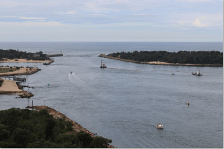
The entrance to the Gippsland Lakes. Permanent dredging is required to keep the entrance open.
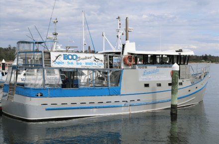
We took a three hour cruise on this very comfortable ship. The cruise was excellent.
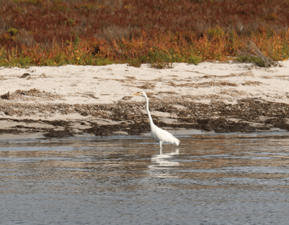
Great Egret
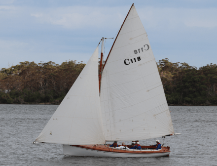
Gaff rigged ‘Couta’ yatch: one of many racing on the Lakes.
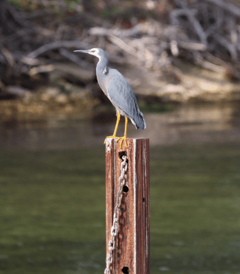
White faced Heron
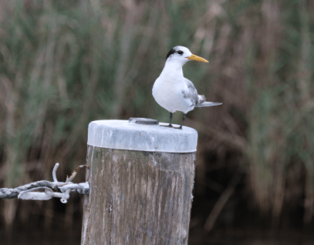
Juvenile Tern
The cruise was excellent for anyone interested in wild life and photography. These are just a few of the photographs I took.
Summary
I was able to activate five Parks (three more towards the Keith Roget Memorial National Park Award) and two SOTA summits conjointly on this holiday trip. The visit to Kara Kara National Park was my second activation.
Once again thanks to all who gave me a call and a special thanks to those who spotted me in the various locations.
Jenny identified sixty species of birds (‘qsos’?) on the trip and her trusty Morcombe Field Guide is nearly falling apart!
Our main objective as a family was to meet at Lakes Entrance. We had booked a cabin for the ‘oldies’ and a camping site for our Sydney family. We left Healesville early as we had arranged to meet Peter, VK3PF, at Traralgon for coffee and to see his new 4 x 4 vehicle. Peter had made some suggestions designed to give us the optimum route to Traralgon and at 10:00 am we were at our meeting place. Peter called on the repeater to indicate he was not far away (and after a three-way contact with Brian, VK3BBB) we were soon enjoying a coffee and chat which extended for an hour and a quarter. Peter was setting off to drive to NSW and we only had to get to Lakes Entrance. It was great to catch up and I really liked the way Peter has set up his vehicle. There will be lots of activations in the future! And there were lots for Peter while he was away on his trip to Queensland which commenced after he left us.
Day one 20th April 2017
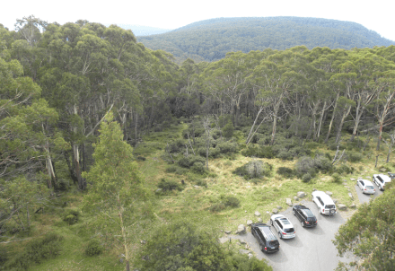
On the 20th the family decided to visit the Buchan Caves. They had a great time and I drove the extra 15 kilometres to the Snowy River National Park to begin my quest for 44 contacts. I wanted to get to this Park in far East Gippsland. On a previous trip I managed to activate all of the National Parks in the East of Victoria with the exception on the Snowy River National Park. One of the Rangers at the Buchan Caves gave me a simple map and after leaving the bitumen road to Orbost from Buchan and taking Basin Road (gravel road in good condition) and then Old Basin Road, I was soon at the Five Ways junction. I took a left hand turn and 300 hundred metres up the road I was soon at an excellent location pointed out by Peter. There was plenty of room, even for the 80m dipole, and absolutely quiet, except for the birds.
The arrangement was that we would meet in Buchan for lunch at 13:00 hours, so I had a bit over an hour for my activation.
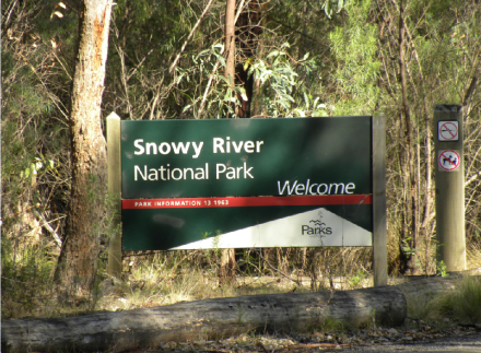
The Park Sign near Five Ways
The Park
The Snowy River National Park is 114,505 hectares and was reserved as a National Park in 1979. It is 390 kilometres from Melbourne. Once again we had the excellent Victorian Government Visitors Guide. I recommend these guides and you can down load them to your personal device.

Five Ways Junction
Contacts
I was soon set up, using a convenient stump as a base for my squid pole and at 00:58 had my first contact with:
7.100 VK7PRN s 59 r 57 I could not spot so I started on 7.100 but soon moved to 7.144 Mhz. I indicated on Sunday evening on ParksnPeaks that I would be activating the Snowy River National Park.
VK2QR
VK2SWL
VK3FOWL/P Julie at a school
VK3SRC
VK3GGG
VK3PMG
VK2YW
VK7PRN
VK2FNLR
VK3SQ
VK3FRAB
VK3FCMC
VK4TJ 52 51
VK2ZTP
VK2NP
VK5PAS
VK2KYO
VK3SFG
VK7DW
VK2VKB
VK5WA
VK3ZMD
VK7JON/M
VK5LDM
VK2IO
VK1AD
VK1NAM
Twenty-eight contacts in an hour with time for a few photographs and then pack-up time and back to Buchan for lunch. All contacts, with exception of that with VK4TJ, were 5 and 8 to 5 and 9 and my received signal an s point less than I gave. The 40m band was in great condition.
After lunch we returned to the Park to spend the afternoon together and try and take some memorable photos. We drove to the Bally Hooley day visitors area. We had the place to ourselves but there was a family camping nearby. I did not try to activate from there as I did not want to disturb campers or day visitors. The junction of the Snowy and Buchan Rivers is a beautiful location. We spent quite a few hours enjoying this iconic part of the Park.
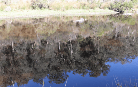
This photo shows some reflections in the Buchan River which was still and there was no wind.

Another view of the reflections.
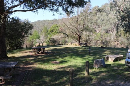
Bally Hooley Day Visitors area which adjoins a camp ground. The track to the rivers begins at this location.
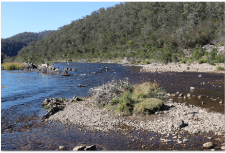
This photo shows the junction of the Snowy (on left) with the Buchan River (on right).

Meanwhile back at the camp I saw this goanna heading for a camper’s tent: when she/he saw me a change of direction was called for. I thought the goanna was used to people and probably lives nearby.
Day Two 23rd April 2017
Our family had to return to Sydney on Saturday as the children were due back as school on Monday morning. We decided to go back to the Park and I set up in the same area as I used on the 20th April 2017.
I was on the air at 00:23 on 40 metres and again conditions were good. I had alerted chasers to my activation the night before.
My first contact was with VK5WOW, operator Hans, VK5YX, 59 and 58. ‘Wow’ was I happy to get a contact with the special event station for the Wireless Institute of Australia Annual General Meeting and Convention to be held in Hahndorf over the weekend beginning 19th May 2017!
‘Wow’ is an exclamation when you are impressed or surprised. It relates to the sub-theme of the convention that ‘Radio is Magic’! We are hoping to create some ‘Wow’ moments over that weekend.
Then followed:
VK3HBZ, John at Bairnsdale, a local. Signals were 5 and 9 both ways.
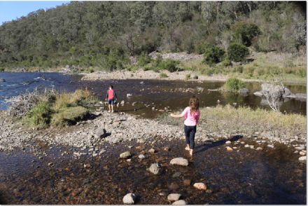
VK3YE/P Peter getting his feet wet!
VK5PAS/P
VK5PE/P
VK5FMAZ/P
VK5HS
VK3SQ
VK2EIR/M
VK2QK
VK2VW
VK2NP
VK2YW
VK2RH/P
VK5FANA
VK2JDR/P
VK5KLV
VK4ARW
VK1AT/3 Raymond Island, Gippsland Lakes
VK4FW/P VKFF-1552
VK3PF/4 VKFF-0129 and SOTA summit VK4/SE-045
VK3TUN/P David at Wyperfeld National Park, VKFF-0549
VK5QI/P Mark at Morgan Conservation Park VKFF-0911
14.310 Mhz
ZL1BYZ 5 and 1 John
40m ssb
VK1AD/P2 SOTA summit VK2/ST-093
VK2IO/P2 SOTA summit VK2/HU-093
VK4RF
VK4HA
VK5CZ/P SOTA summit VK5/SE-010
VK5MBD Bill at Overland Corner at the Riverland Radio Group meeting
VK5ZK, Garry at Goolwa
and finally,
VK1FWBD/2, Wade at VK2/IL-005.
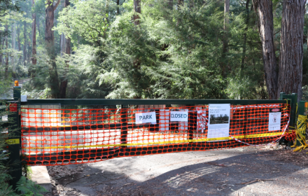
We arrived at Healesville on Sunday afternoon and settled into our accommodation. The next morning the sun was shining and we set off on our expedition to the Yarra Ranges National Park. We had set aside a whole day for the Park and besides activating the Park from two locations, we also planned some bird-watching near the Maroondah Reservoir just out of Healesville. When we arrived at the Park gate to the reservoir there was a notice indicating the area was closed.
So we decided to travel to activation location number two, Mount Donna Buang. We chose to take the longer route from Healesville. Our map showed that some of this route was unsealed. That is indeed what we found. The bitumen road surface stops and the road becomes narrower and gravel, although in good condition. It is certainly useable by a two-wheeled drive vehicle. Care should be taken on the corners, especially on the ascent, and keeping hard left is sensible. We were soon at the summit and I was surprised to see so many people and so many cars.
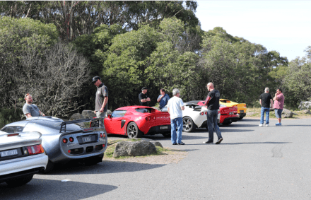
A group of Lotus cars at the summit with their owners and admirers.
We went for a walk looking for an activation spot and I found an unclaimed picnic table which I claimed. It was sheltered from the main area by some trees and shrubs and proved to be a great location. The weather was great!
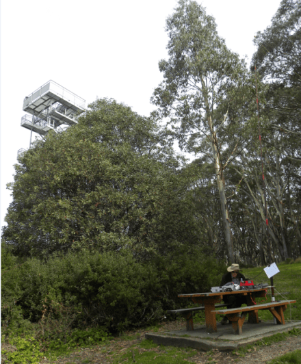
My operating position (JCD photo).
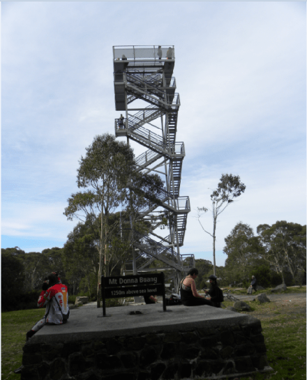
Mount Donna Buang Lookout (JCD photo).
A view from the observation tower: spot the squid pole? (JCD photo).
I set up and was soon on the air. My log is reproduced below and I well and truly qualified the summit and the Park at WWFF level (44 contacts). My operating conditions were my Yaesu 857D set for ten watts, an 80 and 40 metre linked dipole and an IC80AD Dstar/FM hand held radio, potentially for some two metre contacts.
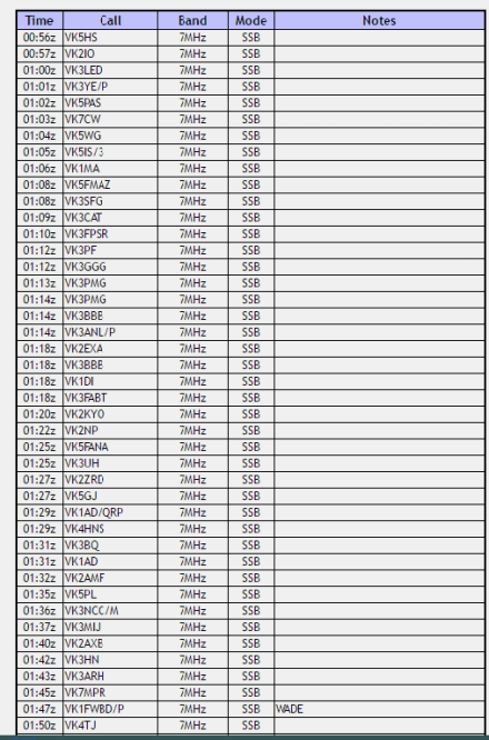
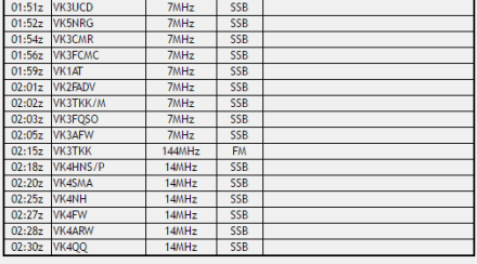
All my contacts are appreciated and thanks to all of the chasers. However the highlight contact was with Peter, VK3TKK on two metres. I used my ICOM HT, set for five watts with a quarter wave length antenna holding the radio lengthwise and parallel to the ground. That is the antenna was parallel to the ground as well. I was standing on the picnic table. What I had achieved was directing the donut-shaped pattern of radiation down the valley towards Melbourne. Peter’s signal was 5 and 9 (from his vehicle) and I received a 4 and 3 report. I was happy with that. I wish to thank Peter for his patience in making this contact. It took a while as I was experimenting with the direction of the antenna. I did not take a compass bearing but I am confident the antenna was broadside to Melbourne. I should have climbed the lookout tower for two metre contacts. But Peter called before I could close down on 40 metres and there were still callers on the frequency.
The twenty metre band was selected to try and work some VK6 stations. I posted an alert but there were no takers. I suspect propagation was not working. I did, however, snare a series of VK4s. Thanks to the VK4s who took time out to give me a call.
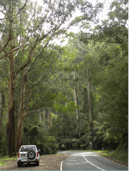
This photo, taken after we left the summit on the Road to Warburton, gives some idea of the magnificent eucalypts in the rain forest. I am standing near the speed sign on the right hand side of the road (JCD photo).
After departing from the summit we took the alternative descent to Warburton and then drove to Healesville making a round trip for the day. The road from the summit is excellent (see picture above) and we were soon at Warburton where we stopped for some refreshments and a break and walked up and down the main street enjoying the sights. Warburton was crowded and the traffic was heavy. There was almost a carnival atmosphere in Warburton and it appeared that this was one of a number of locations that Melbournites retreat to for a weekend drive.
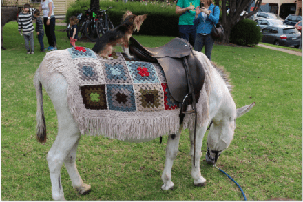
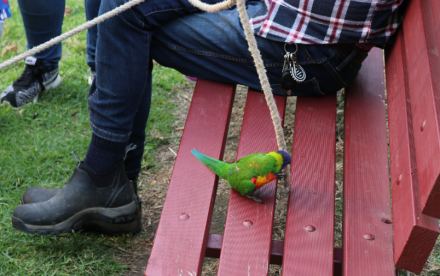
The man on the seat had two donkeys, a dog and a lorikeet employed entertaining the crowds and the animals appeared beautifully cared for and there was not a hat or container in sight.
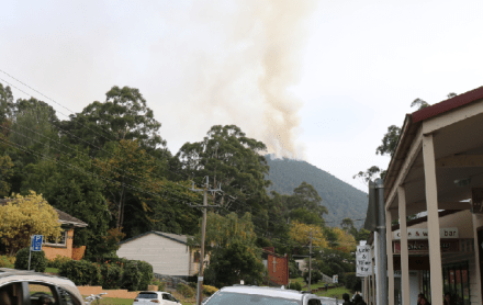
There was also a controlled burn underway on a nearby mountain and the responsible department had two staff members in Warburton, with a stand on the footpath, ready to answer people’s questions about the fire. I was impressed!
All in all a magnificent Autumn day to remember!
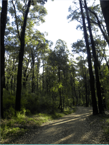
On the 17th April we travelled from St Arnaud via Bendigo with our final destination being Healesville, where we had booked accommodation for two nights to enable the Yarra Ranges National Park and Mount Donna Buang to be activated. Even though it was Easter the roads were not too busy and we found ourselves with some spare time, still allowing arrival at Healesville in daylight. I could feel Kinglake National Park calling! Kinglake National Park is in a number of blocks and we did not think we had enough time to get to Mount Disappointment. We chose the Womelano Block taking Eucalyptus Road off the Melba Highway. We drove back from the Gums Camping Area and soon found another track into the Park which we took. The track is pictured below and the barrier was locked to prevent further access (by vehicles) into the Park. We had the place to ourselves. It was a magnificent location, although as you can see, the trees had been scarred by fire.
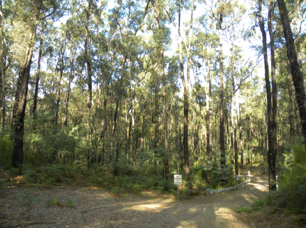
The walking/fire management track (JCD photo).
Burnt trees and re-growth (JCD photo).
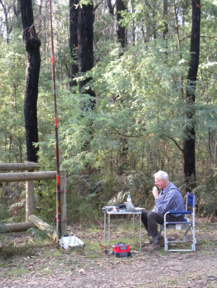
My operating position, about 300 metres inside the Park, near the boot-cleaning facility for Phytophthera which is a ‘fungus-like’ organism that destroys healthy plants in the Park (JCD photo).
My Contacts
I was on the air at 05:29 on 40 metres and chased a few stations before settling down on 7.110 Mhz. I made 32 contacts and conditions were generally good. Another park activated for the Keith Roget Memorial National Park Award and more than ten contacts for VKFF! Here are the stations contacted:
VK5FMAZ
VK5PAS/P Both stations were in Scott Creek Conservation Park, VKFF-0264. I was pleased to get Marija and Paul in the log.
VK6ADF/P, 52 and 51. A pretty good contact with Phil on 40 metres across the continent.
05:39 VK5WOW, Scott Creek Conservation Park, operator VK5PAS.
VK5VRD
VK3GGG
VK3PMG
VK7NWT
VK1DI/P, Ian, VKFF-0988
05:47 VK5AFZ/P, Bob activating Lawari Conservation Park, VKFF-1767, for the first time. See my post on the ‘stolen park’ for more information.
05:49 VK4RF and VK4HA 59 59 Rick, great signals from VK4
VK4FW
VK2HHA
VK4HNS/P, Neil in VKFF-0274 Kwiambal National Park
VK5HS
VK5KC
VK2VIN
VK5KLV
VK7VEK
VK3BQ/M
VK3FQSO
VK5FRHB
VK5RM/M
VK4FFAB
VK2NP
VK5PL/P
VK5YX
VK4SMA
VK2HJW/QRP
ZL4KD 57 57 Ken
ZL3YF 57 57 Margaret
At 06:20 I thought I should close down, pack up and head for Healesville. Thanks to all who gave me a call at Kinglake National Park. All callers are greatly appreciated. I have fond memories of Kinglake National Park and I suspect it was the first National Park I ever activated.

This photo shows VK3BJE activating Kinglake National Park and Mt Disappointment, circa 1978, pre-SOTA and the wwff program. The radio is an early ICOM, an IC 215, a 15 channel two-metre FM radio, putting out three watts. I really enjoyed this radio and providing one kept within a reasonable distance of Melbourne with some elevation contacts were pretty well assured on 146.500 FM and via the repeaters which were really widely used then. My son, Julian, is in the foreground on the left. My rather battered ARRL Minilog shows at least three trips to Mount Disappointment and that I had operated portable on many occasions and locations in VK3 as well as in VK1, VK2, VK4 and VK7. The radio even came with me on interstate work trips in my luggage.
I hope you enjoy my reflection on the past!
On Good Friday we set off on our road trip to Lakes Entrance in Victoria. For the last six years we have gone to various locations in Victoria and New South Wales to spend some time with our son and his family. Our two Grand-children have birthdays late April and we take advantage of the New South Wales school holidays (Victorian school children return to school after Easter) for a relatively quiet break together. Our first stop was at Naracoorte and the next day travelled to St Arnaud where we had booked accommodation. We planned a bird-watching and radio day with sufficient time to explore the Park and activate the West of England Fire Tower summit for the SOTA program. This summit is worth two points to the activator and two points for the hunter.
I previously activated Kara Kara National Park on the second of January 2014 for the WWFF program and the Keith Roget National Park Award. Here is a link to that activation:
On that occasion I took a track off Boundary Road and then a fire track into the Park for about 500 metres. This time we stayed at St Arnaud, about ten kilometres from the Park and we had much more time to explore the Park. We took Centre Road from the end of the Park nearest St Arnaud and drove the track to the turn-off to the West of England Fire Tower track. The final drive to the summit is not a great distance but quite steep for the last few metres and with loose rocks and gravel on the track and some ‘wash-aways’. I think the track would be driveable in a two-wheel drive vehicle with reasonable clearance and careful navigation. I engaged high 4 wheel drive in the Patrol because of the loose stones and some wheel slip.
The Park
Kara Kara National Park, previously known as St Arnaud Range National Park, ‘contains one of the most intact large areas of Box-ironbark vegetation and landscapes in Victoria’ (Victorian Parks Visitors Guide). These Victorian Government publications are excellent and can be down-loaded and printed before you visit or obtained from local visitors centres. The Guide recommends the Centre Road Nature Drive which is approximately 50 kilometres long and takes in adjoining areas such as the State Forest. We took the shorter drive on Centre Road just before entering the National Park (taking Shed Road and the Border Track to join Centre Road).
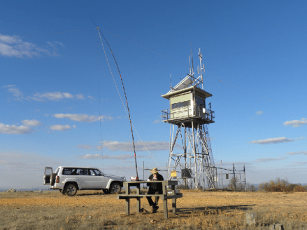
This photo shows my operating position on the summit with a convenient picnic table in place (JCD photo).
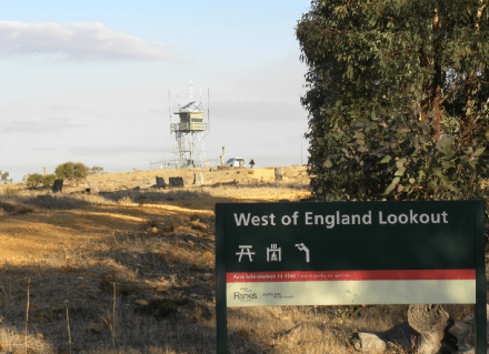
Another view of the summit and Park sign (JCD photo).
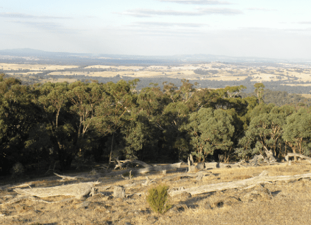
The summit has been cleared of trees to enable views of the surrounding country side for fire spotting purposes and the view are great (JCD photo).
Here is my log of stations for the activation. I managed 45 contacts including two park to park qsos.
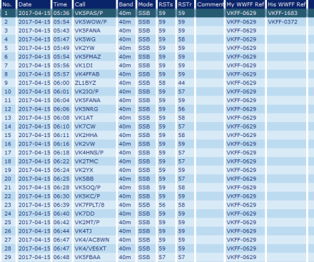
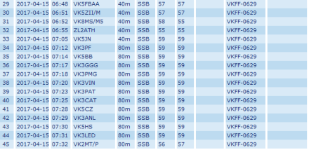
I really enjoyed the activation. Thanks for all who gave me a call and special thanks for those who posted my activation on Parks and Peaks and on Facebook.
